
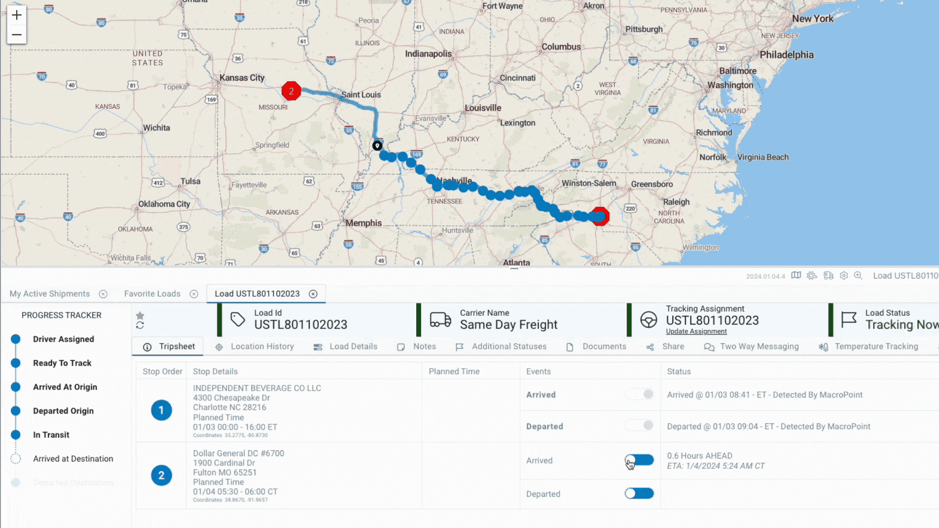
Truckload - Understand the Tripsheet
The truckload Tripsheet is the default tab first displayed when a user drills into a specific shipment. The tripsheet is divided into four categories: Stop Order, Stop Details, Event, & Status. Continue below to learn more about each category👇
Stop Order
Stop Order is the sequence of stops on the shipment. MacroPoint supports multiple stops per tracking session and the order is determined by either how a user configures the stops in the Rapid Track manual set up of a tracking session or by the Sequence Number sent on the Create Order API via integration.

Stop Details
The stop details display all relevant details for pickup and deliveries of the load including stop name, address, city, state/province, & country. All of these details are customer provided details, either manually entered when setting up a shipment or sent via integration.
Note: All Stop Details are visible to drivers utilizing the MacroPoint for Truckers mobile app.

The coordinates listed under the Planned Time are the exactly latitude and longitude coordinates the geofence is plotted for the stop. All stops for all loads are geofenced by default for all MacroPoint customers.

There are three ways a geofence is determined:
1. MacroPoint geocodes the street address supplied by the customer and plots lat/long coordinates determined by Bing Maps. (Note: If the street address is not valid or recognized by Bing Maps, by default the geofence plots to the center of the zip code).
2. MacroPoint can manually input a geofence override for a specific facility to override geocoding. This is typically used for repeatedly used stops with bad address details or worksites with no established street address.
3. Customers can pass geofence coordinates via API integration per stop, per load, which overrides MacroPoint's geocoding and manually inputted coordinates (#1 & # above). The geofence will be plotted at the exact location the customers supplies.
Planned Time
The Planned Time is the date and appointment/window time of the stop, supplied by the customer on order set up.

Events
Events are flags to indicate if an arrival and/or departure has been captured for a specific stop. If the event name is bold and the toggle is gray, the event has completed. If the event is not bold and the toggle is blue, the event has not been captured.
Multiple triggers can mark an event completed.
1. Geofence: A location update is captured within the geofence. Note: A departed event will only be logged via geofence update if the Arrived event is captured. Once MacroPoint receives a location update outside of the geofence after the arrival is captured, an estimated departure time is calculated based on the driver's distance from the top.
2. Driver Reported: Any driver utilizing the MacroPoint for Truckers app has the ability to manually mark arrival and departures from stops. This is default functionality of the app for all customers and cannot be disabled.
3. Carrier Reported: Carriers can report events via integration. If an arrival and/or departure time is stored in a carrier dispatch system, carriers can make an integration call to automatically mark an event completed.
4. Customer Reported: Users are able to manually toggle events to completed status. Simply click the blue toggle and a window appears to pick a date and time.
Key points about Events:
1. Events are captured based on whatever method occurs first. This means if an event is captured via geofence, the driver no longer has the ability to manually check the event via the app. Or if a carrier reports an event completed, geofencing for that specific event is disabled.
2. Once an event is captured, regardless of method, users cannot manually remove the event. If you want to remove the captured event, please email servicedesk@descartes.com for assistance. They can reset the event(s) as needed.
3. Any event reported via driver app, carrier, or customer will automatically create a new location update mirroring the time and date of the update.
Status
The status column logs date & time stamps of captured events along with how the event was captured and displays ETAs to upcoming stops.

Captured Events Labels & Meanings:
- Detected by MacroPoint Geofence captured event
- Reported by Driver Driver clicked event button in MacroPoint for Truckers app
- Reported by Carrier Carrier reported event via integration or manually in their MacroPoint account
- Reported by Customer Carrier reported event via integration or manually in their MacroPoint account
ETAs
ETAs are displayed on all stops where an event has not been captured. Every new location update captured on the load retriggers MacroPoint's ETA algorithm to determine an updated time along with how many hours ahead or behind a driver is to the stop's planned time. Note: If the planned time of the stop is a window (ex: 08:00-17:00), the hours ahead or behind is based on the close time of the stop.